Date: 20th July, 2016 - 29th July, 2016
Expenses: 200 EURO (from Stockholm to Stockholm including travelling) or 2000 Swedish Krona
Expenses: 200 EURO (from Stockholm to Stockholm including travelling) or 2000 Swedish Krona
Trekking time: 5 days
Journey Duration: 9 days
Availability of water: From mountain springs
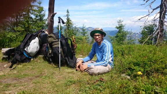
Start of the Trek: Telgárt train station (Slovakia)
End of the Trek: Donovaly bus stop (Slovakia)
Stockholm to Prague (Czech Republic) 1430 km, on a bus operated by Bohemian lines. I started at 13.00 PM on 20th July from the CityTerminalen (Stockholm Bus terminal) and reached ÚAN Florenc Praha (Prague main bus terminal, Florenc) on 21st at 10.45 AM. The highway goes along the lake Vättern (2nd biggest lake in Sweden) along the E4. The star attractions of bus journey were the amazing sights of the Turning Torso (tallest skyscraper in the Scandinavia), Öresundsbron (Oresunds bridge- an engineering marvel connecting Sweden and Denmark), the full Moon in the sky (from the Denmark to Germany ferry) and the picturesque European countryside throughout.
Journey Duration: 9 days
Availability of water: From mountain springs
Start of the Trek: Telgárt train station (Slovakia)
End of the Trek: Donovaly bus stop (Slovakia)
 |
| Telgart Village |
 |
| Direct bus from Stockholm to Prague in Czech |
स्लोवाकिया मधील लो-तत्रास डोंगररांगा- उत्तराखंड मधील जंगल जर सह्याद्रीच्या डोंगरांवर आणून लावल्यावर सह्याद्री जसे दिसेल, अगदी तसेच !! फरक इतकाच कि रस्त्यावर मँगो-बाईट, पार्ले -जी इत्यादि चे प्लास्टिक नाही सापडणार .
 |
| Telgart Train station |
 |
| Start of the trek |
 |
| Warning ! |
Day1 (22nd July, 2016) Telgárt - Kráľova hoľa - Andrejcová (6-7 hrs):
We had our breakfast in the village, close to a mountain spring and started again at 10.00 AM. The initial ascent from Telgárt (885 mtr) till Kráľova hoľa (1948 mtr) is quite steep and took us 3 hrs in total. The signboards, with warning of the bears sightings, can be seen here. First water source can be found just before the Prameň Zubrovice (1650 mtr) direction marker. The 137.5 mtr tall TV tower with tubular mast installed on top of Kráľova hoľa can be seen from this point. Many hikers prefer a day's hike to Kráľova hoľa. The top has a room (to be used during emergencies) especially during bad weather or thunderstorms which happen quite frequently in this region. Its another 3-4 hrs walk to the first shelter, Andrejcová (1420 mtr), and also the next water source. The Higher Tatras Mountains can be seen running parallel (to your right side) of the lower Tatras mountains. We had a short break where I offered Ondrej one of the Moong Ladoo (मुगाचे लाडू). "Coffee with powdered lentils and sugar", this is how he described it !
 |
| View from the ridge. Higher tatras in the background |

We reached the Andrejcová shelter at 4.20 PM (the shelter is on your right-side of the trail). Its a beautiful hut nestled amidst the mountains, offering excellent view of the setting and the rising Sun. We had the cabbage soup with bread and some snacks for dinner (we had to compensate for the skipped lunch). We decided to leave for Ramža hut early morning at 8.00 AM and hence we had to sleep early too. The calculations were simple- Rest from the first day + Energy for tomorrow = 9 hrs sleep !!

 |
| Andrejcova hut |
 |
| Voda = Water |
We woke up at 5.46 AM to find the Sun, already up in the Sky. The sleeping bags rolled-up, bags were packed, and the preparation for the breakfast was in progress. We started a bit early than expected, at 7.37 AM, and decided to use the extra time for lunch.


The trail goes via Pod Kosariskami, climbs to Priehybka (1550 mtr) where you can see a sign on your left, directed to voda (water). Trail further climbs to Velka Vapencia (1691 mtr). We met a cyclist at Velka Vapencia. He had camped here on the ridge (illegally) and claimed to have seen a bear from upto a distance of 100 mtr. The trail is not suitable for cycling and they just have to carry the bike with them. The slope had many loose rocks and the soil made it slippery.
The next descend is through the thick forest to Priehyba (1190 mtr) where lies a mountain stream nearby. We had our first break at Kolesarova (1508 mtr) and the blue berries kept us quite occupied. Instant energy!


We reached Zedna Hola at 1.49 PM. We met another cyclist on the ridge and another couple, who had their dog following them. They informed us about the fallen trees blocking the trail and the delay which it might cause. We guessed another 3-4 hrs to Ramža as per their description and also decided to have the lunch here. The low Tatras National Park was a victim of a hurricane which had caused a major destruction of the forest here in November 2014. Its aftereffects can still be seen even today.
 |
| Dark forest |
 |
| Water from Mountain springs |

The trail from Sedlo Homolka (1533 mtr) to Havrania Polana (1440 mtr) has many small pine bushes and forest patches in between. The fallen trees were slowing down the pace. There is one water source, approximately an hour after Havrania Polana. You will have to climb about 2-3 mtr up to find the nozzle for filling the bottle. We reached Ramža (1270 mtr) at 5.30 PM. I guess the small breaks, fallen trees, lunch break, blue berries etc accounted for the delay.
 |
| Ramza shelter. Dinner in progress. |

The Ramža hut can accommodate about 15-16 people or about 10 people comfortably. The hut is not operated by anyone and the trekkers can stay here without having to pay anything.


Day3 (24th July, 2016): Ramža - Čertovica - Chata M.R.Štefánika (5-6-7 hrs):
(The time depends on how much you rest in Čertovica)
The day started at 6.46 AM. The Sun was, as usual, shining brightly in the sky (already!). This time we had an extra toppings of blue berries with oats. Having filled our water bottles, we departed from Ramža at 8.00 AM.
गवतावर व झुडूपांवर साठलेल्या पहाटेच्या दवामुळे माझे बूट ओले झाले होते. असा प्रकार सेडलो-झा-लेनिवू पर्यंत चालु राहिला. थोडे वाकून पाहिल्यावर कळले कि उजव्या बुटाच्या अंगठ्या जवळचे चामडे फाटले होते आणि पाणी सरळ आत शिरत होते. ट्रेकचा मुख्य टप्पा तर ४थ्या व ५व्या दिवशी होता कारण ट्रेकचे सर्वात उंच चढ व उतार तेव्हाच होते !
 |
| Certovica |
 |
| Ondrej |
A nice broad cycle track from Sedlo za Lenivou (1378 mtr) descends to Čertovica. We reached Čertovica (1238 mtr) at 10.30 AM. Čertovica is like a hill station, crowded with picnickers, motorists, cyclist and of course trekkers (both short and long distance). By the time we arrived, the dark clouds had started to gather and the possibility of thunderstorm was eminent. We had lunch here and a big rest till 1.00 PM. The rains did not stop so we decided to start our next half of the trek in the rains. The trail steeply climbs from Čertovica to Lajstroch (1602 mtr) then again up-down, up-down to Kumstove Sedlo (1549 mtr). Chata M.R.Štefánika (1728 mtr) is another 2hrs of walking on the ridge from here. The gun memorial from the 1944 Czechoslovakia uprising lies just before the M.R.Štefánika hut. We had pitched our tent near the memorial, and a group of scouts also followed us and pitched 5 of their tents.
 |
| Towards M.R.Stefanicks |


Day4 (25th July, 2016) Chata M.R.Štefánika - Ďurková (6-7 hrs):
(Summit of Chopok (2024 mtr) and Ďumbier (2046 mtr). High chances of spotting Chamois or the mountain goats after Ďumbier)
Before the alarm went-off at 6.30 AM, we were woken-up by a man outside our tent, asking us to clear the area ASAP as a Helicopter was going to land here within half an hour. It was hardly 15 min. since we started packing that the helicopter engine broke the morning silence. Later it found a better landing spot than our tent area and after throwing out thick ropes, it took-off again. It was transporting the junk from up here, to a village below and was transporting fresh ration from the same village to up here. A truck loaded with food items was waiting at the foothills. We enjoyed this drama while having our breakfast. We left the M.R.Štefánika at 8.15 AM. We could still see the helicopter making to-fro journey and this continued for more than 2 hrs.
The direct route to Ďumbier from M.R.Štefánika is closed during summer due to excessive erosion and is only accessible from the west. The route opens-up only during peak winter when there is enough snow. The North face has loose rocks, South side has some vegetation and is less rocky.
We reached the top of Ďumbier at 9.30 AM. While travelling from Ďumbier to Chopok, we met a lot of people flooding towards Ďumbier carrying tiny backpacks. The reason- Chopok can be accessed by a ski-lift from a village below. The route, mostly huge boulders and flat rock, looked well maintained. We reached Chopok at 11.00 AM. The weather had started to turn really bad. We could have waited out the rains at the Kamenná Chata, 100 mtr below the summit of Chopok, but instead decided to cover-up as much distance as we can and then rest in Ďurková. The rains didn't show any sign of receding and neither did we. The clouds were crossing over the ridge which deterred the visibility at many times. The misty weather continued for another hour or two. We also missed a left turn and followed a wrong path to the North. Thanks to the GPS and a map which Ondrej was carrying with him we were able to trace back our route. We had a lunch-break at Krížske Sedlo (1774 mtr).


 |
| This was our alarm for today! |
Before the alarm went-off at 6.30 AM, we were woken-up by a man outside our tent, asking us to clear the area ASAP as a Helicopter was going to land here within half an hour. It was hardly 15 min. since we started packing that the helicopter engine broke the morning silence. Later it found a better landing spot than our tent area and after throwing out thick ropes, it took-off again. It was transporting the junk from up here, to a village below and was transporting fresh ration from the same village to up here. A truck loaded with food items was waiting at the foothills. We enjoyed this drama while having our breakfast. We left the M.R.Štefánika at 8.15 AM. We could still see the helicopter making to-fro journey and this continued for more than 2 hrs.
 |
| Sarcasm ??? |
 |
| Rockey, jagged face of Dumbier |
 |
| On the top of Dumbier 2043 mtr. |


As a snack, I offered some Bhakarwadi (बाकरवडी) and some Karachi biscuit (India cookies) to Ondrej. He loved the taste again ! His description, "Bhakarwadi- rolled bread with some spicy + salty filling" and "Karachi biscuit- sweet vanilla flavored cookie".
A mountain goat jumped in suddenly and crossed the trail hurriedly in front of us. It all happened in a blink of an eye. The rains and the cloudy weather were helping us indirectly. The steep climb was less tiring as it would have been, had the Sun been out. It also helped us conserve our water supply. We reached Útulňa Ďurková (1749 mtr) at 5.00 PM. It was a long day for us. But the next day was even going to be longer and more tiring.

 |
| Inside the Hut |
The ॐ symbol at the entrance caught my eye. As I entered the hut, I was even more amazed to see the Ladhaki flags and Buddhist symbols all over the hut. The owner said that it was from the travelers from North India and Nepal.
Day5 (26th July, 2016) Ďurková - Donovaly (7-8 hrs):


The mobile alarm rung at 5.30 AM. We had planned to leave early, by 7 AM. The sky looked less cloudy and we expected a nice weather today. We departed as planned. The view of the mountains and valley and the clouds trapped between them was just mesmerising. We climbed 300 mtr to join the ridge and then followed the ridge via Sedlo Zamostskej Hole (1591 mtr), Sedlo Latiborskej Hole (1540 mtr), Latiborska Hola (1643 mtr), Velka Hola (1639 mtr), the steep climb from Sedlo Pod Skalkou (1476 mtr) to Kosarisko Sedlo (1670 mtr) and the biggest descend from Velka Chochuľa (1753 mtr) to Hiadeľske Sedlo (1099 mtr). There is a water source near the hut here. A cycle track from Donovaly also meets here. The first half of the descend consists of short pine-trees and rocky trail and the second half through forested trail till the Hiadeľske sedlo. We had a lunch break here (12.30 PM). The bright Sun had started disappearing slowly behind dark clouds and we could clearly see a thunderstorm approaching. We waited to see if the clouds recede, but nothing like that happened. Our lunch break turned out to be a really long one, and we left the hut at 2.30 PM in the rains. The trail climbs steeply onto a ridge to Kozí Chrbát (1330 mtr) and down to Hadlanka Sedlo and again climbs to Kečka (1225 mtr) and goes through meadows and fields and finally climbs down to Donovaly. The final leg of the trek was very slippery and filled with mud, and to top it, it was still raining heavily. The sheep and the cattle were happily grazing in the meadows.


हा भाग उतरताना आपल्या महाराष्ट्रातील कळसुबाईची आठवण झाली. पावसाळ्यात जसा रास्ता चिखलाने भरलेला असतो अगदी तसाच इथे हि झाला होता !


We reached the civilization at 4.30 PM. It was another half an hour walk to the bus stop. Our bus from Donovaly to Ruzemberok was at 6.35 PM and the train from Ruzemberok to Prague at 11.30 PM. Train reached Prague at 6.15 AM on 27th July 2016.
The E8 is frequented mostly by the Czechs and by a few Slovaks. I just met a guy from Ukraine and a couple from France throughout the trail (one Indian, which was me). Rest were all passionate Czech trekkers !
Evening in Prague 27th July 2016: Someone of my age would usually visit Prague for boozing the shit out of him/her. In order to avoid such crowd and to experience the real beauty of Prague, I decided to explore the city in the evening (night). To my surprise, the Charles bridge was indeed empty! And also was the old city square.
 |
| Old town square |


 |
| Charles Bridge |
 |
| There are 40 statues, 20 on either side of the bridge |
 |
| On the Charles Bridge |
The Charles bridge, built by the Charles IV in 13th century, bridges the Prague castle with Old town. It is built over the Vltava river. The 621 m long and 10 m wide Stone bridge is made out of Bohemian Sandstone. Only pedestrians are allowed on the Charles bridge. I couldn't help notice a Police car crossing the bridge multiple times.

 |
| Just an empty street @ 2 AM |
Back to Stockholm: I took the night bus from Prague to Berlin, Berlin to Malmo and a SL train (Nattåget) from Malmo back to Stockholm.
 |
| Turning Torso- Tallest building in Scandivania |
 |
| Malmo City in South of Sweden |
Some notes:
Its better to carry Rain jacket and a waterproof pant. Drinking water is usually not a problem throughout the route. The "Beware of Bear" signboards, actually means it, but its not something to be afraid of, if you stick to the trail. Carrying a tent and sleeping bag always helps. Lastly, strictly follow the route markers !!


No comments:
Post a Comment